[Walk] Discovery Trail of Sorède

SOREDE
[Walk] Discovery Trail of Sorède
Easy
1h30
3,1km
+39m
-38m
Embed this item to access it offline
An easy walk through the village streets to explore the heritage of Sorède, along a shaded route. Several stops are possible along the river.
Description
- Starting from the Tourist Office. Cross Rue de la Caserne and head to the Town Hall parking lot. Walk along the Town Hall and take the passageway under the hackberry trees. These famous hackberry trees have brought Sorède renown since the early 20th century and still do today, thanks to the ESAT.
- Climb a few steps and turn left onto Rue de la Maréchalerie. The houses here are typically close together. They formed part of the castle's protective wall, as they were located within 30 feet of the church. In the 1900s, craftsmanship was prominent in the village streets: cooper, harness maker, muleteer, blacksmith, and farrier. On the right, take Côte de l'Église and stop at its entrance.
- The Parish Church. Formerly a seigneurial chapel, it became a church in the 12th century. Its typical Romanesque-style capital is a testament to that era. The church is dedicated to St. Assiscle and St. Victoire, whose relics were brought from Cordoba. The inscription "Populus me fecit" (1733), carved into the capital, indicates its full restoration in the 18th century.
- On Place de la République, walk under the archway and at the end of the street, turn left. Take the first left to return to the square, where you have just circled the castle. The Fortress Building. Fortified in 1299, it belonged to the nobility until the French Revolution. The archway was once the guardroom, and the current Place de la République was the parade ground. These are the only remaining vestiges. Today, it is private property and houses an old oil mill that was used until the harsh winters of 1955-1956.
- Take Rue Saint-Jacques towards the community hall.Rue Saint-Jacques. This street crosses the former "Hortolans" neighborhood (from hort, Catalan for garden). Many gardens were once located here, benefiting from water from a nearby canal. A statue of Saint James, patron saint of gardeners, adorns a house façade. In front of this house, take the alley on the right.
- Rue du Rec Mayral. At the end of the street, you'll discover an ancient irrigation system. The Rec Mayral and its twenty secondary canals made up the village's irrigation network. Using a system of gates, the canals provided water to the nearby gardens year-round. Strictly regulated during droughts, the system still sparks small disputes today. Return the way you came and take the street descending to the left of the Hôtel Les Mas. At the end of the path, you arrive between Mas Miquel (right) and Mas Soula (left). In the past, many isolated mas (farmhouses) surrounded the village, such as Mas Bassole, Mas Florenti, and Mas Tarté. Turn left, then take the first left onto Rue du Mas Soula.
- Opposite No. 20, take the small descending path. Chemin Vicinal No. 8.This path ran along the Albères foothills from Villelongue-dels-Monts. It led to the Sainte-Marie de la Coberta Church, which was washed away in the 17th century. La Font del Bisbe. Translated as "The Bishop's Fountain," it is named after Bishop Cholet, the papal legate who accompanied King Philip III the Bold and his army during the 1285 crusade against the King of Aragon. The bishop rested here, and you can too if you wish! Cross the footbridge and follow the ascending path. Turn at the first street on your right to reach the Mas Félis district. Mas Félix. This area housed one of the first grain mills.
- Follow the main road. Rue du Veinat. This street runs along the river and ascends to Le Christ des Missions. In Catalan, veinat means "neighborhood." This area remained isolated from the village for a long time and was a hamlet in itself. At the end of the street, on your right : Le Christ des Missions. In 1893, wooden crosses were erected following the return of an evangelical mission, hence the name. The road on the right leads to the Notre-Dame du Château chapel. On your left, a small path descends to the river and brings you to the Rouréde (oak grove). Rue des Châtaigniers. This street crosses part of the Formiguer district. Previously, this area featured small mounds surrounded by brush and groves resembling giant anthills. These vegetation piles were ground up to improve crop cultivation. At the first intersection, take the dead-end street on your right. Rue des Micocouliers. This street is named after the tree that brought Sorède fame. In the early 20th century, over 300 Sorèdiens worked making whips, splints, and horse collars from its wood. The factory, the last of its kind in the world, is located on Rue du Stade and is open to visitors free of charge. Follow the path under the trees along the irrigation canal.
- Le Puits du Cap de la Riba. This translates to "Well above the bank." Sorède’s extensive water projects made this well one of the most important due to its location. Its fresh, tasty water attracted many, who often lingered. Ahead, the footbridge (washed away several times) leads to Font del Sabater (Cobbler’s Fountain). Once used to soak leather, it no longer flows as it has been diverted. Near the well, take the sloping path upward.
- Across the way, take Rue du Mas del Rost and turn at the first left. Rue des Acacias. This district features typical houses with terraces, outdoor staircases, and cellars. It was disadvantaged due to the absence of canals. Many families who lived here worked for the whip factory.
- Turn left, then immediately right. Le Quartier du Campet. Literally meaning "small field," this area was named because each house had an adjoining small meadow. Located on the river's right bank, it remains significant as the home of many old Sorèdian families.
- After 100 meters, turn left. Traverse du Campet. This small street features authentic Catalan houses that have retained their charm. The river access here, as in many other places, allowed people to empty chamber pots. At the end of the street, turn left.
- The Bridge. Built over several decades beginning in 1841, this bridge replaced the previous ford near the washhouses where the Tassio River was crossed.
- After the bridge, take the street opposite, Rue du Puits. At the end, turn right and continue to Place Combes.
- Place Combes. This is the current market square. Previously called Place St-Pierre after a saint whose statue was located here, it hosted the grain market. Renamed in 1905, it now honors Emile Combes, a senator promoting secularism. At the butcher shop, continue along Rue du Centre to Place Padre Himalaya.
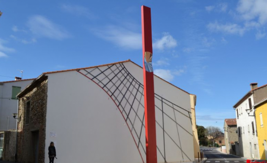
- The Sundial. Inaugurated in 2013, Sorède’s sundial is unique in France, blending creativity and technology.
- Departure : Tourist Office of Sorède
- Arrival : Tourist Office of Sorède
- Towns crossed : SOREDE
Altimetric profile
Recommandations
Make sure to bring water, wear comfortable walking shoes, and protect yourself from the sun with a hat or cap.
Transport
Bus 1€
Access and parking
D618, D11
