Hauts des Forts Trail (Long Version)

COLLIOURE
Hauts des Forts Trail (Long Version)
Hard
3h12
21,8km
+1184m
-1184m
Embed this item to access it offline
Departure from the bay of Collioure, beautiful ascension in the scrubland to go around the forts above Collioure. The end of the route is via the coastal path.
6 points of interest
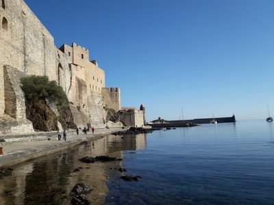
Château Royal - CCACVI  Cultural heritage
Royal Castle of Collioure
Built in the 13th century to house the court of the Kings of Majorca, the Royal Castle of Collioure has been listed as a historical monument since 1922. Reinforced many times, the castle eventually pushed the city back to the foot of the cape turned into a citadel in the 17th century. It is inseparable from Collioure as the city can not be separated from the sea. To return to the heart of the world of the Royal Castle of Collioure, do not forget the guided tours!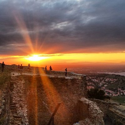
CCACVI Cultural heritageFort Dugommier
Fortress built to monitor the towns of Collioure and Port-Vendres, Fort Dugommier was born in 1893. Because of its strategic location, it sweeps the coast of the eye. However, the Second World War did not spare him by destroying a large part of the fort. He now belongs to an association. Walk pleasant, but beware of the wind because there, it blows!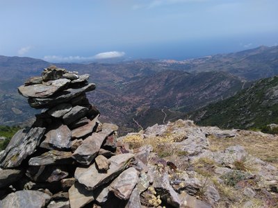
Col de Banyuls - François-Xavier Hallé 
Col de Banyuls-sur-Mer
This incredibly wild and unspoiled site, which serves as the border between France and Spain, has been the scene of many twists and turns in the history of refugees. Discover the beauty of the place and let yourself be amazed by the unique panorama of the site.
CCACVI Cultural heritageErmitage Notre Dame de Consolation
The Hermitage of Our Lady of Consolation dates, according to the oldest writings, to 1496. According to some, the building was built on an old site of pagan worship. Numerous hermitages line the Massif des Albères testifying to the rise of these buildings during the 17th century. This hermitage is also very nice to take a break along your hike. In the shade of the trees, you will be able to take advantage of the place to have a picnic in complete tranquility.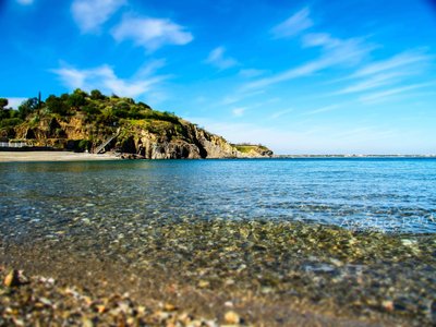
Plage de l'ouille - Aurélie Rubio  Panorama
Ouille Beach
The beach of Ouille, between Collioure and Racou, is a real paradise. This confidential beach is mostly frequented by locals or customers of neighboring campsites. With its small pebbles, it extends about 100 meters below the cliffs of the Côte Vermeille. This beach, very quiet even in high season, however, is not monitored and parking to access is quite far. In short, a great place to be away from the crowd.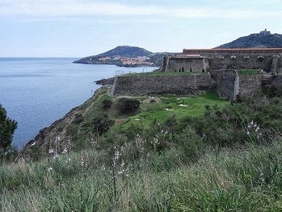
Fort Miradoux - admin66pm Cultural heritageFort Miradoux
In 1669, Vauban who wanted to make Collioure a garrison town, decided to shave the old town and create Fort Miradoux on the site of the old Fort Sainte-Thérèse built around 1540 by Charles V. This fort because of its location was of paramount importance in the defense of the castle. Today, Fort Miradoux, owned by the Army has become the National Commando Training Center (CNEC).
Description
- Start from the beach St-Vincent to the royal castle, follow the sea along the beach and typical neighborhood “le faubourg”. Go up to the Collioure Museum of Modern art in the direction of the Cortina mill.
- Turn left before climbing the stairs surrounded by olive trees that lead to the Cortina mill. Arrival at the glorieta, magnificent view of the bay of Collioure. Take to the right of the glorieta, in the direction of the Cortina mill.
- Arrival at the mill, climb the path that leads to fort St-Elme that rises in front of you. Continue on this path that passes under the fort, until the first crossing, go straight. At the second crossing turn left, climb the asphalt road that runs along the forts. Take this old road, which goes to the left of fort Dugommier.
- Arrival at the Col d’en Raixat (218 yards), take the path on your left. magnificent view from the other side of the Collioure’s forts. Follow this path around the Puig de les Daines (364 yards). Magnificent panorama over Port-Vendres, Banyuls sur mer far away, the fort Béar and the Madeloc tower. At the first crossing take the rising path on the right, then go down to the col Mollo (252 yards) by the very steep dirt trail in the middle of the vegetation at the next change of direction (dangerous descent).
- Arrival at the col Mollo (252 yards) take the earth path that rises before you in the junction of the two roads. Follow this trail on the crest of the mountain that offers a magnificent view of the Vermeille coast. Once at the summit, turn left, Taillefer’s battery is above you.
- Take the second path on the right which goes up on the crest of the mountain, magnificent view on the Vermeille coast on the left, and the Ravaner valley on the right.
- Follow the path that rises to reach the peak of the mountain until reaching the summit and the Madeloc tower (713 yards). You’re here at the highest point of the track. Here you have a 360° view of the Vermeille coast, the Ravaner valley, the Pyrenees and Spain can be seen in the background.
- Go down the old asphalt access road in front of you until you reach the stone building in a turn. Take the path on the left of this edifice that joins the Coll Gascons (422 yards).
- Take the road on your left to join the Coll Vallauria (459 yards). Once reached, take the second path on your right that descends into the valley (be careful of your choice). Follow this path on the side of the mountain. At the crossing to go up to the Coll Tallaferro (508 yards), continue straight to go around the Taillefer’s battery until you reach the Col Serra (371 yards).
- Once reached the Col Serra (371 yards), take on your right the asphalt road for 300 yards to reach a big rock at the edge of the road, take the path behind this rock to reach Consolation.
- Go down to consolation through the forest, follow the path (difficult passage). Arrived at Consolation take on the right the road that goes down to the bottom of the cliff. Follow the river “le dui” towards Collioure with the asphalt trail that follows the river.
- Arrive in the city center. Take the direction of the stadium by the asphalt road that rises, follow the stadium and then take on your right. Arrival on the fort Carré trail. Follow the trail to the fort. Continue on the path on the other side that leads to the fort Rond.
- Go down to the road, take on your right to reach the old road that goes down to the beach. Follow this one to reach the old road that goes down to the beach. Follow this one to reach the “plage de l’Ouille”.
- Arrived at “plage de l’Ouille” take the stairs that stands in the cliff on your right (difficult crossing). Arrive on the coastal path that runs along the sea. Advance to Collioure while seeing Fort Miradou. Take the path on your right to return to the road.
- Take the road along the stadium to go down to the town of Collioure. Turn left at the first roundabout and follow Fort Miradou to reach the old Collioure’s streets.
- go down to the church of Notre Dame des Anges and its bell tower through the narrow streets. Once you have reached Saint-Vincent beach, return to the royal castle.
- Departure : Saint Vincent beach
- Arrival : Saint Vincent beach
- Towns crossed : COLLIOURE, PORT-VENDRES, BANYULS SUR MER, and ARGELES SUR MER
Altimetric profile
Recommandations
Remember to hydrate. Do not stray from marked trails. Do not throw anything in nature.
Transport
Busses 1€
Access and parking
D914
Parking :
Glacis car park