The border crossing via the GR 10

ARGELES SUR MER
The border crossing via the GR 10
Very hard
4h30
28,9km
+2066m
-2065m
Embed this item to access it offline
Do you love wild places where the forest is silent? Are you addicted to the challenges of summits where panoramic views are the reward? Set off to conquer this loop trail with over 29 km and 1800m of elevation gain.
6 points of interest
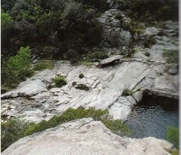
Gneiss leucocrates dans le lit de la Massane - Guide ADT  Geology
Le champ filonien du val de la Massane
The wild gorges of the Massane are dug through the most metamorphic rocks (transformation of minerals under the effect of pressure or temperature) of the Massif des Albères. The most remarkable geological character is the presence of numerous leucocratic magmatic injection veins (rock made up of clear minerals). These veins are of all sizes but one of the most remarkable, of kilometer size, outcrops at the foot of the Tower of Massane (BRGM).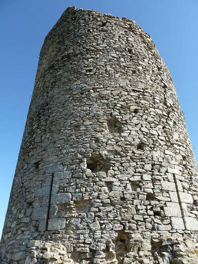
CCACVI  Cultural heritage
Tour de la Massane
This watchtower, built by the Kings of Majorca, offers an exceptional point of view on the Plaine du Roussillon. At 793 meters altitude, the tower is a landmark for hikers of the massif. The famous Cassini cartographer even used it as a geodesic landmark in 1701 for his meridian work. He manages to find a difference of 397 toises between the foot of the Tower and Collioure (an altitude of 780 meters). Rather precise for the time, no?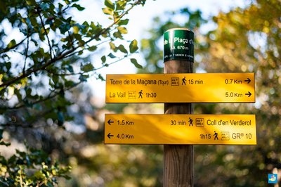
Benjamin Collard 
Col de la Place d'Armes
The Col de la Place d'Armes (Coll de la Placa d'Armes), located 677 meters above sea level, is a strategic point serving two distinct paths: on one side the path leading to the forest in the reserve de la Massane, and on the other the Tower of Massane. Rest for a moment in the shade on the rocks before making your route decision!
Croix frontière 588 - jean-Philippe Lapeyre  Small patrimony
Border Cross 588
This cross is located at Coll de Terrers. Border markers and crosses have marked the boundary between France and Spain since 1856 (Treaty of Bayonne, or Treaty of Limits). Linked together, they span a length of 623 km from the Atlantic to the Mediterranean, forming a rich vernacular heritage. For more information, you can consult Jean-Philippe Lapeyre’s books Randonnées Mégalithiques Volumes 1 and 2 (click here to view points of sale).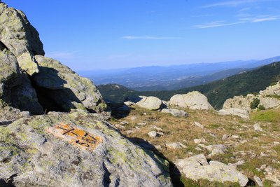
Croix frontière 587 - jean-Philippe Lapeyre Small patrimonyBorder Cross 587
This cross is located at Coll de la Maçana. Border markers and crosses have defined the boundary between France and Spain since 1856 (Treaty of Bayonne, or Treaty of Limits). Connected together, they span 623 km from the Atlantic to the Mediterranean, forming a rich vernacular heritage. For more information, you can consult Jean-Philippe Lapeyre’s books Randonnées Mégalithiques Volumes 1 and 2 (click here to view points of sale).
Croix frontière 587 - jean-Philippe Lapeyre Small patrimonyBorder Cross 587
This cross is located at Coll de la Maçana. Since 1856, border markers and crosses have delineated the boundary between France and Spain (Treaty of Bayonne, or Treaty of Limits). Linked together, they stretch 623 km from the Atlantic to the Mediterranean, forming a rich vernacular heritage. For more information, you can consult Jean-Philippe Lapeyre’s books Randonnées Mégalithiques Volumes 1 and 2 (click here to view points of sale).
Description
Take the route from the St. Laurent Chapel (Sant Llorenç) PR® ARG4.
- Pass the Mimosas campsite, the Mas Blanc, and begin the ascent on the DFCI-AL N°39 track. At the intersection of the two tracks, take the DFCI-AL N°28, pass the cistern, and take the path on the left that climbs into the cork oak forest. A much wider path leads to an opening where the ruins of Mas Pardès appear.
- Turn left (south) onto the well-marked path that leads to Roc del Grill - Torre de la Maçana (Tower) PR® ARG1 and follow this route all the way to the Tour de la Massane.
- Descend through the scree to reach the Coll de la Place d'Armes. Follow the Rimbau PR® ARG3 trail, which plunges into the beech forest, and emerge at the Coll d’en Verderol (776m). Continue on the route, passing the water catchments of the Font (spring) d'en Cassanyes and the Font d'en Vergès (the tunnel is bypassed).
- As you follow the GR®10 along the ridges of the massif, the 360° panorama of both Catalonias (North and South) is exceptional when the sky is clear (beware of strong winds). Admire the holly sculptures created by the Massana cows. Pass the peaks of Sallfort (978m), Carbassera (1,000m), and Quatre Termes (1,158m). The Font de la Maçana: Altitude: 968m / GPS coordinates = 31 T 500638 E 4701972.
- Reach the GR10 milestone "Puig dels Quatre Termes," then descend north to the Col des Trois Hêtres (Coll dels Tres Faigs). This is the intersection where the DFCI-AL N°18 track ends. Continue north, descending to reach the Coll de l’Aranyó and the Roc (rock) de les Medes.
- At the base of the rock, to the left, is La Font (spring) dels Miracles, at the foot of a large, tall beech tree. Climb back up the trail and then begin the descent (steep and sharp) towards the hamlet of Lavail.
- Arrive at the Massane river, cross at the level of the St. Martin Chapel. Head right at the end of the paved road that leads into the hamlet, then take the DFCI-AL N°35 dirt track. Arrive at the parking lot, follow the signage marked "La Vall PR® ARG6." Make sure to close the gates behind you, as cattle are present year-round. The path climbs steadily up to Roc del Grill.
- The route then descends to reach Valmy.
- Departure : Valmy parking lot
- Arrival : Valmy parking lot
- Towns crossed : ARGELES SUR MER, SOREDE, and BANYULS SUR MER
Altimetric profile
Recommandations
Bring snacks and sufficient hydration. Check the weather conditions. Take all your waste with you.
Every year, the 'Argelès Nature Trail' association organizes nature sports challenges (hiking, trail running, nature races, etc.) on the last weekend of April. This friendly event takes place in the Albère massif and around the Valmy municipal park: https://www.argelesnaturetrail.com/.
Every year, the 'Argelès Nature Trail' association organizes nature sports challenges (hiking, trail running, nature races, etc.) on the last weekend of April. This friendly event takes place in the Albère massif and around the Valmy municipal park: https://www.argelesnaturetrail.com/.
Transport
Bus 1€
Access and parking
D 914, exit 12, Château de Valmy
Parking :
Château de Valmy Parking Lot