The "Roc del Grevol" and "Puig d'Orella"

LAROQUE DES ALBERES
The "Roc del Grevol" and "Puig d'Orella"
Hard
5h42
12,9km
+963m
-962m
Embed this item to access it offline
A challenging hike that allows you to discover, from the summits, a magnificent panorama of the coastline with resorts such as Argelès-sur-Mer or Saint Cyprien, the Roussillon plain, and Mount Canigou, the sacred mountain of the Catalans
1 point of interest
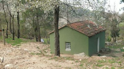
CCACVI  Refuge
Casot del Guarda
This summary hut is located 533 meters above sea level. With its concrete table and the opportunity to picnic outside, it will be a perfect resting place during your hike. It is possible to sleep on the large table or on one of the concrete benches. The nearby river can be useful as is the chimney in the refuge.
Description
- From the Tourist Office, Maison de la Randonnée, head towards the Church following the yellow markings.
- Take the small alley facing the Church gate, then the path that climbs up the massif. On the right, you'll pass the Moulin de la Pave (old mill), and a few meters higher, a charming shaded fountain, the Fontaine des Oiseaux, or Font dels Ocells in Catalan. The path follows a half-buried canalization. Reach a fork, then turn right. Here, there's a small water reservoir.
- At this trail junction with informative signs, take the direction towards DOLMEN – PIC NEULOS – COL DE L'ULLAT. On the left side of the trail, there's a small irrigation canal that you should follow until you reach a strategic trail crossroads.
- Turn right at this crossroads, following the trail that descends towards the river. Cross the river at a ford, then the path ascends to reach a small paved road.
- There are informative signs here. Turn left in the direction of Pic d'Orella.
- Continue on the left track (DFCI AL 11). Follow it for 150 meters. Then, take a right onto a trail (marked with yellow signs). Leave the track behind. The trail climbs steeply through a beautiful rocky valley. The path progresses along the ridge. The view is clear, and the panorama of the plain and the sea is superb. Reach an intersection of trails.
- Continue on the trail that climbs along the ridge towards Roc del Grèvol, leaving a path on the left indicated by a sign for Fontaine de la Vernosa. The trail continues to ascend, with some steep sections.
- Prominent rock: Roc del Grèvol (902 m). Beautiful view of the plain. After the rock, the trail reaches a track, which you need to cross to continue on the path, still along the ridge, leading to Puig d'Orella. Elevation: 1030 m.
- Stunning panorama. From the peak, descend along the ridge towards the southeast, in the direction of Col de l'Ullat.
- Col de l'Ullat. Picnic area, hostel chalet. From the pass, head towards the Laroque side (east) and follow the paved road down to a fountain located below this road.
- Reina de las Fonts Fountain. The return path to Laroque starts from this fountain. Follow the yellow markings. The trail descends rapidly under the beech trees, crosses a ravine, then progresses under the chestnut trees. The descent will lead you to cross a forest track four times. The trail approaches the Laroque River and crosses it at a ford. The path passes near an ice well and continues to descend.
- The trail crosses the Correc de les Teixoneres, a narrow passage between two rocks, once used by shepherds to count their animals.
- A few meters further, you'll reach a trail intersection. Descend straight ahead.
- Intersection. Leave the right path (marked with a yellow cross) and continue the descent on the left trail. You'll reach the strategic trail intersection that you started from at the beginning of your hike. Continue descending towards the village following the same route.
- Departure : Tourist Office of Laroque-des-Albères
- Arrival : Tourist Office of Laroque-des-Albères
- Towns crossed : LAROQUE DES ALBERES and VILLELONGUE DELS MONTS
Altimetric profile
Recommandations
Bring water, snacks or a packed meal, a hat, a windbreaker, and sturdy walking shoes. Consider the elevation gain and check the weather before setting out! Please carry your waste with you.
Transport
Access and parking
Access via D2, D618, and D11.
Parking :
Hikers' parking at the stadium