The Ouillat Col

LAROQUE DES ALBERES
The Ouillat Col
Hard
6h
13,3km
+938m
-937m
Embed this item to access it offline
Le Col de l'Ouillat has a pleasant climate year-round, as it is rarely snowy and quite cool in the summer. Here, the Corsican pine forest and splendid landscapes provide a complete change of scenery.
Attachment
- Downloadpdf
Randonnee-Col-de-l-Ouillat
Credit: Flyer Randonnée Col de l'Ouillat - OT Laroque
1 point of interest
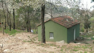
CCACVI  Refuge
Casot del Guarda
This summary hut is located 533 meters above sea level. With its concrete table and the opportunity to picnic outside, it will be a perfect resting place during your hike. It is possible to sleep on the large table or on one of the concrete benches. The nearby river can be useful as is the chimney in the refuge.
Description
- From the Tourist Office, Maison de la Randonnée, head towards the Church and the center of the village. Facing the Church gate, take Church Street, a dead-end, followed by the trail, bordered on the left by a stream. The trail exits the village. On the right, you'll pass the Pave Mill (old mill), and a few meters higher up, you'll find a lovely shaded fountain, the Fountain of Birds. The trail follows a partially buried pipeline. Upon reaching a fork, take the right path towards a small water reservoir.
- Arrive at a trail intersection. Information signs. Take the direction of DOLMEN – PIC NEULOS – COL DE L'ULLAT. On the left side of the trail, there is a small irrigation canal that needs to be followed until reaching a strategic trail junction. The sound of the river can be heard below.
- Take the left trail. Notice a blue and white wooden marker. The path ascends through the vegetation. YELLOW MARKINGS. Intersection.
- Continue the path that ascends to the right, always following the yellow markings. Another trail intersection. Yellow writing on a stone on the ground. Take the trail in front. Narrow passage between two rocks (Portell Estret), formerly used by shepherds to count their animals. The path, still marked in yellow, continues south, with a slight ascent. Narrow ledge with beautiful panoramas of Laroque.
- The trail crosses a first ravine and then the river: Correc de les Teixoneres. It then climbs in switchbacks. Nice stone wall to the left of the trail, preceding a trail intersection marked by a "PISTE" sign.
- Continue to the right. Always follow the wall; a bit further on the left, the sign indicates the presence of an ice well a few meters above. Continue on the same path. Cross the watercourse.
- Continue straight ahead.
- Follow the markings.
- Follow the sign for Col de l'Ouillat.
- Trail fork. Take the left trail that steeply ascends to reach a forest track. Cross it and take the trail that ascends steeply ahead. Arrive at a new forest track. Cross it and continue on the trail, which ascends more gradually. Follow the yellow markings. Small ravine to cross. The trail continues to ascend under the the Corsican pine trees.
- Reina de les Fonts Fountain. Spring below a small tarred road. Picnic area. Follow the road to the right to reach Col de l'Ullat (in Catalan).
- Refuge chalet and restaurant at the Col de l'Ouillat. Beautiful place, ideal for barbecues and relaxation. RETURN via the same path.
- Departure : Laroque Tourist Office
- Arrival : Laroque Tourist Office
- Towns crossed : LAROQUE DES ALBERES
Altimetric profile
Recommandations
Take water, snacks or a picnic, a hat, a windbreaker, and sturdy walking shoes. Consider the elevation gain and check the weather before departure! Carry back any waste.
Transport
Access and parking
D2, D618 et D11
Parking :
Hikers' parking at the stadium