(E 12 - GR 92) Rosas - Cadaqués
(E 12 - GR 92) Rosas - Cadaqués
Medium
7h
19,8km
+740m
-741m
Embed this item to access it offline
Path along an urban promenade, connected by a footbridge, passing by the beaches and coves of the Cap de Creus Natural Park to the cove of Joncols, place from which the path becomes interior to Cadaquès
1 point of interest

OT Llança  Cultural heritage
Château de la Trinité
Military construction located at the end of the Poncella, dating from 1544. It was built during the reign of Emperor Charles I, in addition to the citadel. In the shape of a 5-pointed star. At the time, it had three terraces for batteries of cannons, howitzers or mortars at different heights to defend the port and the coast, with a garrison of two hundred men. Today, this extraordinary example of an artillery fortress can be visited and constitutes a spectacular watchtower of the Bay of Roses.
Discover the guided tours and the offers for families.
Description
- From the Roses Tourist Office, located right next to the majestic citadel of Roses, follow the seaside promenade towards Puig Rom.
- Pass the marina and, arriving at the fishing port, look up to see the remains of the 16th century Trinity Castle.
- At the Roses lighthouse, leave the sidewalk and descend to the right into the lighthouse access plaza. The road follows the coast between buildings on the left and very interesting geological formations. The bay of roses accompanies you.
- Pass on Canyelles beach, cross it and follow the covered path leading to Bonifacio beach and to the end of Almadraba beach.
- Leave Almadraba Beach and climb the stairs to Diaz Pachero Avenue. Here, turn right and continue for about 100 meters until the intersection of rue Gauguin which goes up. About 100 meters away, there is a street on the right, partially paved, which leads to the access to the Cap de Creus Natural Park. You can see a sign indicating the park with the red and white marks of the GR.
- Then leave the street and take the coastal path that runs along the coast above the cliffs and offers a spectacular view of the bay of Roses.
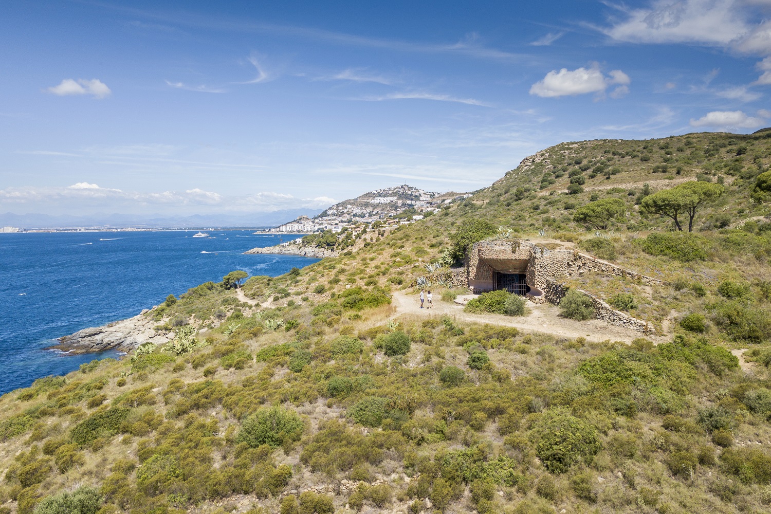
- Arriving at the area of Punta Falconera, point of view and point of vigilance of maritime traffic of the Spanish army (1944-1993), where they built a coastal battery.
- Follow the path passing over Cala LLedo, an old marble quarry. The path is hilly, taking the coves of Murtra, Rostella, Calis and Cala Monjoi. Here in Cala Montjoi you can see the works of the Bulli Foundation, where the famous restaurant El Bulli was located.
- Cross the beach and take the track, where vehicles circulate, for a few meters to Punta de la Ferrera, place where you have to leave the track and take the path, located closer to the sea.
- Cross Cala Calitjas and Cala Pelosa, the site of a prison camp during the Spanish Civil War. Here, the road climbs and crosses Cap Norfeu, an integral reserve of the Cap de Creus Natural Park.
- Cross the track again to descend by the path, leaving Cala Canadell at the bottom right and continue on the path that goes inland to Cala Joncols.
- From there, the path is completely interior. As you advance, you can observe, at the top right, the Mas de Sa Sala and, in the distance, the cliff area of Punta Prima. Cross the Mas d'en Bastre (restored farmhouse with some dry stone buildings) following the track. Soon we begin to catch a glimpse of Cadaques bay and the easternmost part of Cap de Creus Follow the track that leads to the entrance to the old Rocamar hotel. From there, follow the promenade to the Casino, the epicenter of the cultural and social life of this fishing village. Right behind you is the Cadaquès tourist office. End of the route.
- Departure : Tourist Office of Rosas
- Arrival : Tourist Office of Cadaquès
Altimetric profile
Recommandations
Recommended all year long if weather permits. It's better to practise it eaarly in the ùmorning in summer because of the low vegetation and the lack of trees . It is a route combining natural area and urban area, as well as mountainous area and It is advisable to bring good shoes and water or a drink to hydrate.
Is in the midst of the park
The national park is an unrestricted natural area but subjected to regulations which must be known by all visitors.
Transport
Access and parking
18 km from Figueras. Access by the C260
Parking :
Free parking behind the citadel of Roses (except Sunday morning day of the weekly market)