The Retirada and the Paths of Exile (From Port-Bou to Cerbère)

The Retirada and the Paths of Exile (From Port-Bou to Cerbère)
Medium
2h18
5,2km
+415m
-416m
Embed this item to access it offline
This superb hike along the border offers magnificent views of the sea, from Cap de Creus to Cap Béar, as well as the mountains and the small port villages of Port-Bou and Cerbère. Memorials along the route indicate that this path was taken by many exiles fleeing Francoist Spain or German-occupied France. A visit to the Art Deco, ocean-liner-style hotel, 'Le Belvédère du Rayon Vert,' is highly recommended.
3 points of interest
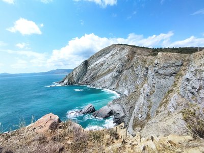
Elisabeth Coste  Geology
The cliffs of Cerbère
The Cliffs of Cerbère are among the highest in Europe and are part of the Banyuls to Cerbère Ecological and Faunistical/Floral Natural Area (Zone Naturelle d'Intérêt Ecologique Faunistique et Floristique des Falaises de Banyuls à Cerbère). Located in the southern part of the Côte Vermeille, this protected area stretches across 7 kilometers of coastline between Banyuls-sur-Mer and Cerbère, covering 140 hectares.
This rugged coastline is oriented from north-northwest to south-southeast and is predominantly made up of schist. The cliffs are sharply cut and are followed by numerous reefs and underwater islets. Several prominent capes punctuate the coastline, including the Cap de l'Abeille, Cap Redéris, Cap de Peyrefite, and Cap Canadell, which demarcate several sandy coves. The most significant of these is Peyrefite Beach.
The summit plateaus are covered with Mediterranean vegetation, including grasslands and maquis scrubland, which are often intersected by temporary streams. This diverse and ecologically significant landscape is a haven for a wide range of plant and animal species, making it an area of great natural interest.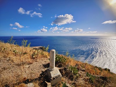
Camille Reynaud  Small patrimony
boundary stone n°601
The boundary markers 601 and 601bis are part of the 602 boundary stones and crosses that delineate the Franco-Spanish border. These markers represent the last accessible land-based boundary points before the border reaches the Mediterranean Sea. The marker 602 is located in the Foradada Cave in the sea, between Cerbère and Port-Bou.
These boundary stones were established following the Treaty of the Pyrenees in 1659 and the Treaty of Bayonne in 1856, which set the current course of the border.
To reach boundary stone 601, one should follow the customs path (sentier douanier). Upon reaching the sign marking the end of the path section, continue straight ahead (following the yellow cross) rather than turning right onto the dirt track. This will bring you to the boundary stone, allowing you to experience this historical marker along the French-Spanish border.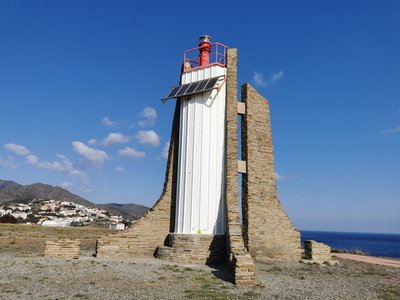
Elisabeth Coste Small patrimonySolar Lighthouse of Cap Cerbère
The last lighthouse before the French-Spanish border, this structure, built in 1982, replaced the old Cerbère lighthouse, which was decommissioned in 1980. Also known as the “Solar Lighthouse” due to its power source—photovoltaic cells—it has a range of 15 nautical miles. To preserve the landscape, all external electrical wiring was excluded from the site. Don’t miss this lighthouse, recognizable by its grey stones and tall red top.
Description
Take the train from Cerbère to Port-Bou. Train schedules.
From the station, head to the Port-Bou cemetery, where the Walter Benjamin Memorial is located (feel free to enter the cemetery to visit his grave).
Face away from the sea and take the stairs to reach the Rambla on the right.
At the 'Voramar' restaurant, turn left and walk along the beach to join the GR-92 coastal trail.
At this point, turn left and follow the path to the Col des Belitres.
Cross over and continue towards the old customs officers' path.
Begin the descent to the solar lighthouse at Cap Cerbère.
Continue along the trail overlooking the sea, which then connects to the road leading to the Cerbère Tourist Office.
Head back to the train station parking lot.
- Departure : Walter Benjamin Memorial (Port-Bou)
- Arrival : Tourist Office of Cerbère
- Towns crossed : CERBERE
Altimetric profile
Recommandations
Bring water, hiking shoes, a windbreaker (regardless of the time of year), and a cap. Be cautious near the cliffs of Cerbère. Take your litter with you.
Transport
€1 bus to Banyuls-sur-Mer, line 540. Shuttle from Banyuls-sur-Mer to Cerbère, line 546. Train from Cerbère to Port-Bou for the outbound journey.
Access and parking
D 914 (France), N-260 (Spain)
Parking :
Cerbère train station parking